By: Carol Hofer, NBCT
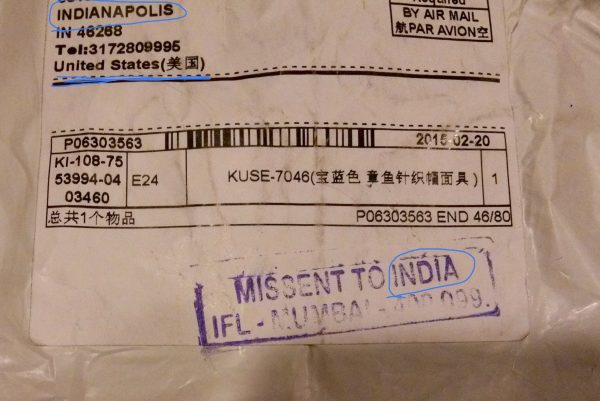
It’s one of my “ha, ha” photos – a snapshot of a package addressed to me, who lives in Indianapolis, with a prominent stamped notice in all caps “MISSENT TO INDIA.” A stamp for this actually exists – it lead me to wonder how often it’s needed. Under Indianapolis it did say “United States,” but hey, India, Indianapolis, Indonesia… they’re all somewhere on planet Earth.

National Geography Awareness Week, as many may not be, ahem, aware, is celebrated every second week in November. While it’s a fun time to highlight some wacky geography trivia, such as Australia is wider than the moon or that most of the U.S. coastline is in Alaska, Geography Awareness Week should be the start of moving beyond trivia and memorization and taking a deeper look into why geography matters and how we should teach it regularly.
- Make it developmental. For Kindergarteners, everything is big, and their whole world is really what is around them. Begin by introducing the cardinal points – post in your classroom where north, south, east and west are, and have your colleagues do the same. Go outside and show your students these cardinal points in the playground and landmarks to help them remember them, and show how the sun can help us figure out where we are. Ask caregivers to help students identify the cardinal points in their home.
- Compare geographical units to spaces kids know and understand. You can say, “our classroom is like a city, and our grade level is like a state, and our school is like a country.” They will grasp these concepts more readily.
- Visibility leads to usability. Place maps and globes within reach, no matter what subject you teach. Globes and maps can help students choose settings for their stories or hone their math skills by calculating the distances between places they would like to visit.
- Talk about the differences between maps and globes. Why do we have both? Though they are similar, we don’t use tongs and pliers for the same task. Same with maps and globes.
- Choose quality, up-to-date maps and globes. Just like you don’t look like that photo of yourself taken 15 years ago, neither does the Earth. Also, find maps that have Alaska and Hawaii where they actually are. There are many students who think Alaska is located in a square off to the side of the mainland states.
- Collect the stickers from fruit to discover all the places our food comes from. Ask why does the same type of fruit come from different places? Look at the tags on our clothing – can we locate these countries on our map or globe? How far do these products have to travel to get to us?
- Use Google Earth. If the name of a place comes up in your curriculum, spend a few minutes finding where it is, and seeing it. With Google Earth, you can fly in from space, land, and become a pedestrian in your chosen location.
- Keep track of daylight amounts around the world. How much daylight is lost and gained where and when? This helps students understand seasons, the tilt of the Earth, and think about where we are in the world affects our everyday life. The loss and gain of sunlight doesn’t happen in equal amounts throughout the year, and students enjoy predicting the quantities once they see the timing trends.
- Demand details. Africa is not a country, but a vast 54-nation continent. We shouldn’t accept vagueness, but instead delineate more descriptively where specifically in Africa we’re talking about.
Geography creates acceptance. My student named Asunción felt singled out by her unusual name. At the end of the day we walked to the big wall map in our school, and I pointed, “This is the capital of Paraguay!” Students looked next to my finger and saw “Asunción.” “Yes,” I said. “She has a capital city named after her!” Let’s embrace the power of geography and its ability to unite us in understanding, accepting, and appreciating our diverse world during this upcoming Geography Week!
